 Loading... Please wait...
Categories
New Products
-
 US $1,550.00
 -
 US $1,885.00
 -
 US $7,980.00
 -
 US $1,455.00
 -
 US $8,995.00

Our Newsletter
- Home
- Total Stations
- Topcon ES 105 5 Second Reflectorless Total Station
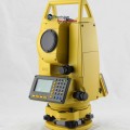
Topcon ES 105 5 Second Reflectorless Total Station

Product Description
The Topcon ES 105 5 Second Reflectorless Total Station is a reliable and precise surveyor's measurement device. It will calculate angles and distances of up to 1,640' when used in reflectorless mode, and if using a prism up to 13,123'. The accuracy of the single prism method is as great as 2mm + 2ppm, with most readings done in less than one second.
The Topcon ES 105 5 Second Reflectorless Total Station has a rechargeable battery that has a charge time of 36 hours. Since it will be used outdoors, it is designed to be water and dust-proof, with an IP-66 rating. Not only is it safe from the elements, it is also safe from theft, as it is linked to the TSshield website. This allows you to lock the system to keep someone else from using it.
With a 10,000-point memory storage, the Topcon ES 105 5 Second Reflectorless Total Station will be able to handle your data in the field. It is simple to transfer data through the USB and serial ports. It is also compatible with other Topcon field controllers, including the FC-25, FC-250, FC-236, FC-2600, and the Tesla.
Features for the Topcon ES 105 5 Second Reflectorless Total Station
- Reflectorless
- 1,640' range
- Transfer data via Bluetooth, USB, or serial port
- Rechargeable battery good for 36 hours
- IP-66 rating against water and dust
- Black and white LCD display
- Keyboard for data entry
- TSshield system
- Laser pointer and plummet
- LongLink for system updates
Specifications for the Topcon ES 105 5 Second Reflectorless Total Station
| Weight | 12.3 lbs (5.6 kg) |
| Dimensions | 7.5 in x 7.5 in x 13.7 in (19.1 cm x 19 cm x 34.8 cm) |
| Warranty | 2-year |
| Protection Class | IP66 (dust proof and powerful water jets and heavy seas resistant) |
| Internal Memory | 10,000 points |
| Guide Light | Green and red LED; Operating time: 1.3 to 150 m (4.3 to 490 ft) |
|
Angle Measurement
|
|
| Minimum Reading | 0.5-second/1-second |
| Accuracy | 5-second |
|
Distance Measurement
|
|
| Unit of Measure (distance display) | m/ft |
| EDM Accuracy (Precision) | ±(2mm + 2ppm x D) for prism; ±(3mm + 2ppm x D) for no prism |
| Minimum Reading | 500 m (1,640 ft) |
|
Tilt Sensor/Compensator
|
|
| Range | ± 6 |
| Type | Liquid |
| Method | Electronic Automatic |
|
Battery/Power
|
|
| Power Source | Rechargeable Li-ion battery |
| Battery Life | 36 hours |
| Battery Life Alert | yes |
|
Telescope
|
|
| Length of Tube | 6.7 in (17.1 cm) |
| Image | Erect |
| Diameter of Objective Lens (Aperture) | 1.9 in (48mm) EDM |
| Magnification | 30x |
| Field of View | 1 degree 30 arcmin |
| Resolving Power | 2.5 arcsec |
| Minimum Focus Distance | 1.3 m (4.3 ft) |
| Reticle Illumination | 5 brightness levels |
| Reflectorless | yes |
|
Display and Keypad
|
|
| Type | Black and white LCD |
| Sides | Dual |
| Keys | Alphanumeric |
| Backlight | yes |
|
Temperature
|
|
| Operating | -4Fº~140ºF (-20ºC~60ºC) |
|
Applications
|
|
| Surveying and Construction | yes |
| Mapping and GIS (geographic information systems) | yes |
| Utilities | yes |
| Environment Studies | yes |
| Geomarking | yes |
| Archaeology | yes |
| Accident Reconstruction | yes |
|
Measurement Range (under fair weather conditions)
|
|
| Single Prism | 4,000 m (13,123 ft) |
| Triple Prism | 5,000 m (16,404 ft) |
| No Prism | 500 m (1,640 ft) |
| Mini Prism | 500 m (1,640 ft) |
| Reflector Sheet | 500 m (1,640 ft) |
|
Functions
|
|
| Coordinate Measurement Point | yes |
| Angle and Distance Stake Out | yes |
| Stake Out Line | yes |
| Offsets | yes |
| Missing Line | yes |
| Remote Elevation | yes |
| Resection | yes |
| Area Calculation | yes |
|
Measurement Time
|
|
| Fine | 0.9-second |
| Rapid | 0.7-second |
| Tracking | 0.3-second |
|
Laser Plummet
|
|
| Accuracy | ±1.0 mm/1.3 m |
| Class | 2 |
| Wavelength | 635 nm |
|
Interface
|
|
| Bluetooth | Class 1 LongLink technology |
| USB | Type A and mini B |
| Pin Port | RS-232C |

Customers Who Viewed This Product Also Viewed
-
 US $1,540.00
 -
 US $3,110.00
 -
 US $4,450.00
 -
 US $2,010.00
Add to Wish List
Related Products
-
-

-
 Nikon NPL322 5 Reflectorless Total Station US $3,330.00
 -
Futtura TS 100 Reflectorless Total Station US $1,540.00
-
South NTS 332R Reflectorless Total Station US $1,550.00